| Developer: | SERGEY BEZDENEZHNYKH (5) | ||
| Price: | * Free | ||
| Rankings: | 0 | ||
| Reviews: | 0 Write a Review | ||
| Lists: | 1 + 1 | ||
| Points: | 14 + 75 ¡ | ||
| Points + 1 | |||
Description
")
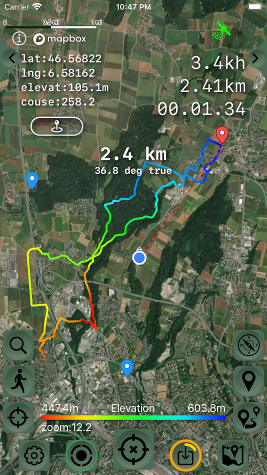
The main functions of the application:
- new fast engine from MapBox.
- convenient and fast loading of maps.
- support for UTM coordinate system.
- route planner.
- pedometer with viewing data for the last three months (steps, distance).
- determination of the height of any waypoint.
- search by address.
- search by coordinates.
- compass.
- processing and optimization of tracks.
- loading and unlimited storage of maps of the travel area.
- supports all import and export methods available for your device with services, friends and applications in .gpx format.
- color gradient for speed and height, if this information is in the imported track.
- color gradient for speed and height for recorded tracks.
- recording speed and altitude in the track.
- relief contours in outdoor mode
- extended track information: average and maximum speed, track duration by time and distance, number of waypoints and number of steps.
- different units of measurement: miles, kilometers, feet, meters.
- pedometer when recording a track and saving information.
- work in the background.
- viewing one or more tracks in any application mode, including the recording mode of another track.
- installation, editing, deletion of waypoints in any application mode and anywhere.
- the ability to adjust the quality of the track, distance filters, energy saving mode.
- export and import of tracks and waypoints to various services - Open Street Map and others.
- has a pointer to the target waypoint and shows the distance to it. Easy target waypoint selection in several ways.
- display of additional information on the screen - scale, coordinates, height, speed, number of steps.
- shows the current distance traveled by the track and the travel or walk time.
- has several map styles - satellite, streets, combo and dark.
- Supports dark theme.
- easy start and stop of tracking in several ways.
- the ability to continue any previously recorded or imported track.
- several modes of map orientation - by the heading of the phone, in the direction of travel, centering and to the north.
- Possibility of tilting the map with double pinch.
- quick and easy selection and viewing of saved tracks, waypoints and maps.
- speed and altitude graphs can be scaled and scrolled.
- in the settings link to the user manual .
- Terms of service: https://appsupport.store/terms/
- Privacy policy: https://appsupport.store/
Screenshots


What's new
- Version: 4.6.7
- Updated:
- -minor bug fixes
Price
-
*In-App Purchases - Today: Free
- Minimum: Free
- Maximum: $9.99
Track prices
Developer
- SERGEY BEZDENEZHNYKH
- Platforms: iOS Apps (5)
- Lists: 2 + 1
- Points: 32 + 177 ¡
- Rankings: 0
- Reviews: 0
- Discounts: 0
- Videos: 0
- RSS: Subscribe
Points


Rankings
Not found ☹️
Lists
Reviews
Be the first to review!
Additional Information
Contacts
- Website:
 https://appsupport.store/
You may also like
-
- GPS Live Navigation & Live Map
- iOS Apps: Navigation By: Erasoft Technology
- * Free
- Lists: 0 + 0 Rankings: 0 Reviews: 0
- Points: 0 + 80 Version: 3.8 GPS Live Navigation & FreeMaps with voice navigation, live map, traffic, offline Gps & direction. Map GPS navigation route directions location live car driving satellite view. Maps is ...
-
- Gaia GPS: Mobile Trail Maps
- iOS Apps: Navigation By: TrailBehind
- * Free
- Lists: 0 + 0 Rankings: 0 Reviews: 0
- Points: 1 + 29,976 Version: 2024.5 Whether you re out in the snow or exploring scenic hiking trails and amazing offroad routes, Gaia GPS has you covered. Spend less time looking at your phone and more time taking in the
-
- Location Tracker - GPS Tracker
- iOS Apps: Navigation By: SHELL INFRASTRUCTURE PRIVATE LIMITED
- Free
- Lists: 0 + 0 Rankings: 0 Reviews: 0
- Points: 1 + 72 Version: 1.5 Location Tracker is a GPS map tracking app. Mark and save your car location, hotel location, and other locations so you'll know how to get back there if you need a reference guide or ...
-
- GPS & Maps: Location Tracker
- iOS Apps: Navigation By: Kraus und Karnath GbR 2Kit Consulting
- Free
- Lists: 0 + 0 Rankings: 0 Reviews: 0
- Points: 1 + 1,898 Version: 4.2 GPS & Maps is a simple, yet powerful GPS app for supporting navigation and outdoor activities like geocaching, sailing, skating, trekking, biking or traveling by airplane. It measures ...
-
- MapXplorer: GPS, Radar, Route
- iOS Apps: Navigation By: Goldlab Applications Yazilim Bilişim Anonim Şirketi
- * Free
- Lists: 0 + 0 Rankings: 0 Reviews: 0
- Points: 0 + 1,369 Version: 1.8 MapXplorer: GPS, Radar, Route App is the offline map app designed to make your journeys stress-free and efficient. With powerful features like offline map, radar, and route expertise, ...
-
- onX Hunt: GPS Hunting Maps
- iOS Apps: Navigation By: onXmaps, Inc.
- * Free
- Lists: 0 + 0 Rankings: 0 Reviews: 0
- Points: 1 + 175,602 Version: 24.15.1 Home to the most trusted and accurate satellite and topo maps, onX Hunt is a fully-functioning GPS navigation app on your phone. View private and public property land ownership data, ...
-
- Find my car - Gps Car Tracker
- iOS Apps: Navigation By: Warrance Tougas
- Free
- Lists: 0 + 0 Rankings: 0 Reviews: 0
- Points: 0 + 80 Version: 2.6 Revolutionize Your Drive with Our App: Real-Time Car Tracker, Live Speed Meter, and Smart Parking Solutions! Stay ahead with live speed updates, avoid fines with speed camera ...
-
- Spyglass
- iOS Apps: Navigation By: Pavel Ahafonau
- $5.99
- Lists: 4 + 1 Rankings: 0 Reviews: 0
- Points: 2 + 3,777 Version: 3.17 Spyglass is an essential offline GPS app for outdoors and off-road navigation. Packed with tools it serves as binoculars, heads-up display, hi-tech compass with offline maps, ...